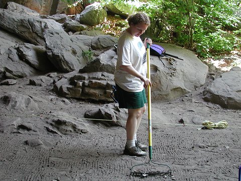
Archaeogeophysics at Rockhouse Cave (3CN20) By Rockhouse Cave, located in Petit Jean State Park in west-central Arkansas, contains some of the best-known examples of prehistoric rock art in the state. The pictographs and petroglyphs found there have attracted tourists, educators, and researchers for decades. Unfortunately, foot traffic has kicked up clouds of fine dust that coat the shelter walls and many layers of graffiti left by careless visitors have defaced the fragile, ancient images. Four decades of such accumulations were removed during a major conservation effort undertaken by the Arkansas Department of Parks & Tourism in September 2000, and plans were made to construct walkways inside the shelter to reduce the dust problem and divert visitors away from sensitive wall areas within the shelter. To assist in designing the walkways and determining their placement, it was necessary to delineate the larger extent of buried archeological features discovered during limited test excavations conducted in 1986 by the Arkansas Archeological Survey. To minimize the destructive impacts of additional excavations, the Arkansas Department of Parks & Tourism arranged with the Survey for a remote sensing investigation of the interior of Rockhouse Cave using a variety of archaeogeophysical technologies. Here we report on the results of that investigation. For decades, geologists and engineers have used various geophysical remote sensing and prospection techniques to determine what natural properties lay beneath the surface of the earth. Comparatively recently, archeologists have begun to use the same techniques to "look" beneath the ground for signs of historic and prehistoric human land use. Archeology, as a discipline, is moving toward a new operational paradigm that stresses minimizing disturbances to archeological sites and other cultural resources whenever and wherever possible. Of course, excavation is still a vital component of the overall process of learning about past cultures. The advent of near-surface prospection technologies in archeological research is nonetheless revolutionizing the way archeological sites are located and studied. Archeologists are now using technologies such as ground penetrating radar (GPR), magnetometry, electrical resistivity, electromagnetic conductivity, and magnetic susceptibility to help pinpoint excavations in search of specific site features, while minimizing impacts to the site as a whole. These technologies have been used to locate entire prehistoric villages and to delineate internal features such as house orientations, ceremonial areas, pottery kilns, and pathways and trails. In open areas that today have no surface evidence of prior human occupation, archeologists are now able to learn much about ancient lifeways and human landscapes even before shovels and trowels come into use. When archeological excavations are required, the ability to visualize the layout of an archeological site before any soil is removed has proven to be an invaluable tool that can save tremendous amounts of time and money while maximizing research and management objectives. Archeological geophysical techniques represent one more tool for minimizing damage to sites while gaining new insights concerning the people and events that produced those sites. Our application of these techniques in Rockhouse Cave began when our team arrived at the site on the morning of June 19, 2001. Crew members were Mike Evans, Jami Lockhart, Jared Pebworth, George Sabo III, and Michelle Berg Vogel. We found the sediments on the shelter floor to be extremely dry and littered with modern metallic debris (soda can pull tabs, etc.), presenting conditions incompatible with the environmental requirements of geophysical prospecting. Our first task, therefore, was to sweep the entire shelter floor with a metal detector to assist in locating and removing the metallic debris. Following that, we gently raked the surface sediments in an effort to retrieve more of the modern debris. We made additional metal detector sweeps until we felt satisfied that most of the modern debris had been removed.
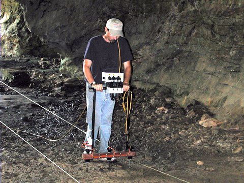
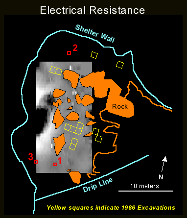
Ben Swadley, Bill Long, and Steve Dunlap of the Arkansas Department of Parks and Tourism joined us later in the morning and together we dampened the shelter sediments with 400-500 gallons of water brought by truck to a nearby parking lot. We must note here that Rockhouse Cave is not a "dry" shelter despite the typically desiccated condition of near-surface floor sediments. Sediments along the back of the shelter are perpetually damp from seepage that enters the shelter through porous bedrock deposits, and previous excavations reveal that much of this moisture drains out the front of the shelter through subsurface sediments. Only the near-surface sediments in the large central part of the shelter are typically dry. These sediments are highly disturbed and contain a mixture of prehistoric and modern items. Our next task was to relocate two iron rebar grid control points from our 1986 excavations. Since these, too, would disturb the geophysical prospecting equipment, the iron bars were replaced with long wooden dowels set with the tops just below the floor surface. We then used a digital Total Station to lay out one 10x20 m and two 10x5 m rectangular areas for geophysical prospection. The largest of these units extended across the part of the shelter that receives the largest amount of visitor traffic. Large boulder piles inside the shelter made it necessary to offset the geophysical grid from the 1986 excavation grid. Measurements necessary to correlate the two grid systems were collected with the Total Station. During the next two and a half days we gathered three geophysical data sets using electrical resistance, magnetic susceptibility, and electromagnetic conductivity. As previously mentioned, the geophysical grids were oriented to take advantage of the internal layout of the shelter, but also to more fully encompass the area of a proposed walkway, which is being considered in order to diminish future impacts to the rock art resulting from heavy tourist traffic within the shelter. Archeological sites are the product of formation processes operating over an extended period of time. Sites and their physical properties also are transformed by natural processes and by human behavior at the site long after its original use. These transformations are commonly exaggerated and complicated in rock shelters as a result of thousands of years of successive and intensive use — prehistoric, historic and modern — in a contained space. In the ground, the archeological record is a three-dimensional volume composed of physical properties associated with sedimentary layers and their differential textures and moisture retention capacities, biogenic and biochemical components, and human-induced features such as burning, compaction, and artifact distributions. Using geophysical equipment, these physical properties — which differ within and between archeological features — can be precisely located, quantified and imaged. At Rockhouse Cave, we collected electrical resistance data using a Geoscan RM15 configured in parallel twin mode. This means some of the probes inject an electrical current into the ground while others measure the voltage (figure 5). The ratio of voltage to current is electrical resistance. The underlying bedrock of Rockhouse Cave's floor appears to have a generally concave shape with shallow soil development at the shelter periphery and ever deeper deposits with increasing distance from the walls. Considering the specific coverage area within the shelter and the results of the 1986 test excavations, we selected a 25 cm probe spacing that determines peak sensitivity at approximately 25 cm of depth.
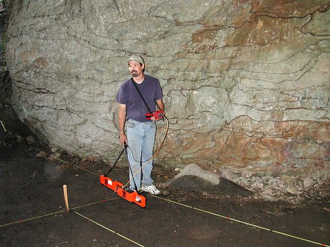
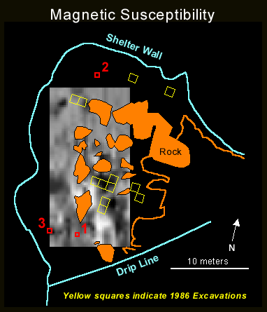
We used a Geonics EM38B to collect electromagnetic conductivity (figure 3) and magnetic susceptibility (figure 6) data. This machine gathers both data sets simultaneously. Electromagnetic conductivity uses separate transmitter and receiver coils instead of probes, and measures how easily an injected electrical current can be made to flow through materials within a column of earth. Signal penetration is determined by the distance between the coils; maximum depth with this particular device is about 1.5 m, with peak sensitivity at approximately 40 cm. Magnetic susceptibility measures how easily different materials are magnetized when exposed to a magnetic field. Depth of penetration for magnetic susceptibility using this device is somewhat more shallow than for conductivity, but is particularly useful in locating subsurface burned areas, as well as other biogenic and biochemical properties often associated with human activities.
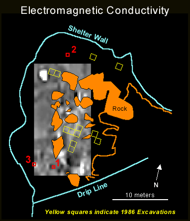
The geophysical data sets were processed and georeferenced within a geographic information system (GIS). Using this process, we can display the data along with other physical features of the site (i.e., shelter walls, dripline, rocks, and excavation units). The figures shown here compare imagery from the three technologies in a 10x20 m area.
The geophysical imagery depicts the areas in which significant anomalies were detected. Three of these areas correspond with the backfilled locations of test units excavated in 1986, indicating the larger extent of archeological features (compacted occupation surfaces and burned areas) identified in those units. We excavated three new 50 x 50 cm control units to investigate the anomalies that did not correspond with previously identified archeological features. We plotted in each control unit with the Total Station and entered the coordinates into the GIS so any finds could be correlated with the geophysical data sets. All excavations were in 10-cm levels. The excavators took Control Unit 1 to a depth of 50 cm beneath the shelter floor. The first 10-cm level was disturbed sediments comprised of fine sand and silt with modern glass fragments as well as prehistoric stone tools, including a pitted "nutting stone" and an Early to Middle Archaic era Big Sandy point. Part of a burned feature (fire-reddened sediments mixed with charcoal) identified as a recent campfire extended out from the southern edge of the unit; this campfire was the subsurface feature the remote sensing equipment had registered as an anomaly. It disappeared in the second 10-cm level, where a large mussel shell was found. Toward the bottom of the third level, at 28 cm below the surface, the mixed sediments gave way to a coarse, sandy sediment with a few novaculite flakes. Small sandstone cobbles occurred in this sediment in the fourth and fifth levels, indicating that we had reached the top of a layer of decomposing bedrock. Digging in Control Unit 2 stopped at a depth of 10 cm, when we encountered the top of a degraded sandstone deposit. The first few centimeters of this unit consisted of a dark brown sandy sediment with modern glass, paper, and plastic debris. The subsurface anomaly registered in this area appeared to be a slightly reddened, degraded sandstone rubble concentration extending part-way across the unit at a depth of 3-5 cm; this feature may represent a historic or modern campfire. Control Unit 3 was excavated to a depth of 30 cm. The first level consisted of disturbed, fine sands and silts that covered a thin, shallow ash layer containing modern glass fragments along with a few chert flakes. The lithics continued into the second level, consisting of coarser sand mixed with small sandstone cobbles. These sediments extended down to a degraded sandstone deposit at 30 cm depth. All three control units produced evidence of buried campfire features, all comparatively recent in origin, directly over the anomalies detected by the remote sensing equipment. The geophysical prospection results from Rockhouse Cave show that remote sensing technologies can be used at some rock shelters to trace the extent of buried cultural features, despite the extensively disturbed sediments at many of these sites. Here, we registered a series of anomalies representing backfilled test units, buried prehistoric features including compacted occupation surfaces and burned areas, and buried historic and modern campfire remains. One long side of the 10 x 20 m geophysical grid, representing the path taken by most people who enter the shelter, also produced a distinctive geophysical pattern that our equipment detected. |
| Home | Quick Facts | Interpretations | Articles | Technical Papers | Resources | Database | Just For Kids | Picture Gallery | Buy the Book! |
|
Last Updated: April 24, 2007 at 10:35:29 AM Central Time
|

