|
Photogrammetry at The Narrows By PREFACE (February 10, 2002) I was approached in December of 2001 and asked to allow this brief report on rock art recording using photogrammetric techniques to be placed on the Arkansas Archeological Survey's rock art Web site. That, of course, was fine with me, and a privilege, but I felt a short background on this paper and a mention of the current state of photogrammetry as it relates to cultural resources would be helpful to the reader. The original report, presented here with some minor revisions, stemmed from some of my earlier work on recording in situ cultural features, in this case, rock art. It was written to be included as an appendix to a report produced by the Arkansas Archeological Survey in cooperation with the U. S. Forest Servive (Project No. 935; April, 1997) entitled Archeology of Rock Art at the Narrows: Specialized Use of a Rock Shelter in Crawford County, Arkansas (Hilliard et al. 1997). My initial introduction to photogrammetry as a tool for recording and analyzing cultural materials occurred in 1994 while a graduate assistant at the Center for Advanced Spatial Technologies (CAST) at the University of Arkansas. At that time, very little was published on the use of photogrammetry as a tool for cultural resources. Much of what we learned and developed is still very applicable and is the basis of what I use professionally today. However, as one might imagine, moving from a studio situation used for recording single artifacts or osteological materials to the field introduces many new problems. Control of the subject is very limited in the field and every site or feature is different and demands a unique approach or setup. Therefore, over the last several years, we (C Dimensions) have developed, designed, built, and utilized much new equipment and many approaches for the recording of cultural subjects, such as historic and prehistoric structures, additional rock art sites, prehistoric features, and human burial features. Additionally, we have generally moved to larger format films, although we still find 35mm films useful for some projects. As stated below, they do produce very acceptable results and the original project at CAST specified low-cost equipment as a major objective of the project. While it has only been a few years since I originally wrote the following brief report on the Narrows rock art site, "photogrammetry" is a term that is heard much more commonly now than it was then, and the term will likely experience even more use in the near future. This fact can mostly be attributed to the rapid development of computers and a stronger trust and reliance on digital data. I still strongly believe in, promote, and use the strengths and potential of photogrammetry as a tool for recording and analyzing complex or fragile cultural resources; no other technology can currently capture and display three-dimensional data with the quality and accuracy of stereo photogrammetry. I look forward to more widespread use of photogrammetry as a recording and analysis tool for cultural resources personnel. Eben S. Cooper Rock Art Recording at the Narrows: Experimentation with a Close-Range Softcopy Photogrammetric Technique INTRODUCTION The study of rock art has not been prominent in archaeology until recent decades (Whitley 1996; Bock and Bock 1991). This has partially been attributed to a lack of ability to interpret these often abstract cultural works. It must be remembered, however, that all prehistoric cultural remains were relatively un-interpretable in the past. For example, until comparable data and other information were available for study, little could be learned from lithics and other material remains. Growing professional and public interest has, however, brought this valuable and fragile resource to a new level of archaeological interest. Because of this increased public and professional interest in rock art, the accurate recording of these sites is essential before they are further damaged or before preservation or conservation methods are determined and applied (Price 1989). Pilles correctly points out that, "[r]ock art sites in particular have seen a dramatic increase in visitation with resultant damage to the resource and the environment" (Pilles 1989:34). An important factor that has hindered the forward movement of rock art studies has been the lack of chronological placement of individual sites. Unlike the dating of many other archaeological features, there is no methodology for relative temporal placement of these works (i.e. stratigraphy). Radiocarbon dating was not applicable to rock art in the recent past; however, with the advent of accelerator mass spectrometry (AMS) and other forms of direct dating (i.e. cation-ratio dating), some rock art sites can now be accurately placed within the chronological record. This development, along with greater public and professional interest in rock art has allowed rock art research in the United States to emerge as a valuable and viable area of archaeological study. Another primary limiting factor in rock art research is the lack of comparable data between sites and regions. A non-intrusive, reliable, accurate, cost effective, and time efficient method to record rock art sites is needed. Recording methods must be easily implemented in the field and yield accurate, comparable, metric data and detailed information. It is, therefore, critical that fragile rock art resources be recorded in a non-intrusive, accurate, reliable, comparable, and easily shared manner. While this is undeniably a difficult task, this paper will briefly discuss one method, photogrammetric recording, that preliminarily appears to solve many of the difficult problems traditionally associated with rock art recording. The Photogrammetric Recording Method The American Rock Art Research Association has developed a Code of Ethics that states that all rock art recording shall be non-destructive (Hedges 1989:35). Until recently, potentially destructive methods of recording rock art have been routinely used (e.g. chalking, aluminum paint, latex moulds, etc.). However, with a greater understanding of the fragile nature of rock art, these methods are now discouraged. Many other traditional and commonly used recording methods are under scrutiny (e.g. tracings, rubbings and grid plotting) because they also might generate potential damage to sites (Hedges 1989). These methods are, however, the only commonly used low-cost and reliable methods of recording sites with relatively accurate scale and detail. In addition to its value for recording, the approach proposed here also provides a method of archiving black and white and color films along with high resolution digital images. This non-intrusive technique will provide a basis for data transfer between researchers, allow quantitative monitoring of site destruction (from both natural and human causes) for use in preservation strategies, and become a database structure from which information can be served to rock art researchers regionally, nationally, and world wide over electronic information vehicles such as the Internet. Photogrammetry is basically defined as: "...[T]he art, science, and technology of obtaining reliable information about physical objects and the environment through processes of recording, measuring and interpreting photographic images and patterns of recorded radiant electromagnetic energy and other phenomena" (Wolf 1983: 1). Many readers will be familiar with parlor glasses that were popular in the early part of this century or at least the toy called a "ViewMaster." Both of these are common examples of a stereo-pair technique that allows one to perceive a three dimensional image. Additionally, almost all contour maps are produced using stereo-photogrammetric techniques. All of these examples rely upon the acquisition of overlapping photographic images or stereo pairs, thus, this technique is referred to as stereo-photogrammetry. While there are other methods of gathering information from photographs such as convergent or monoscopic photogrammetry, this work will deal only with stereo-photogrammetric methods. The fact that the photographic images were captured from slightly different perspectives allows the perception of three dimensions to the viewer. This is very similar to the manner in which human beings are capable of viewing their environment in three dimensions. Both the left and right eye capture a slightly different scene as they are viewed from slightly different positions. The brain then calculates the geometry and allows us to view and judge distance in three dimensions. However, unlike the ViewMaster, parlor glasses, and our own eye/brain combination, capturing and processing overlapping images (stereo pairs) of rock art not only allows the perception of three dimensions, it also permits the retrieval of very accurate three dimensional measurements. All of the specific research and information needs of the future can never be anticipated while in the field. Therefore, it is necessary to develop the ability to view and accurately measure rock art images as research questions demand. The use of photogrammetric technology tackles the non-trivial task of recording rock art in a non-intrusive, cost-effective, and reliable manner. It is beyond the scope of this work to explain fully the principles of photogrammetry and photography but a few basic elements will be briefly discussed. For a full discussion, see photogrammetry texts such as "Elements of Photogrammetry" by Paul R. Wolf. Photogrammetry is based largely on the geometric relationship between the position of points on the film plane(s) and the position of those same points in the real world. Photogrammetry and Cultural Resources There have been a few experimental forays into the recording of rock art utilizing non-intrusive photogrammetric techniques (Mendonca 1992; Rivett 1983; Turpin and Dennet 1979). These experiments were successful and gathered good three-dimensional information. They proved the effectiveness of photogrammetry as a method of recording and analyzing rock art; however, little has been done to follow up this method of recording rock art sites. The primary reasons for this are: (1) the great expense of metric cameras (e.g. Wild P31/P32 and Zeiss Jena UMK); (2) the necessity for stereo plotters to gather graphical information and measured drawings (these are not only expensive but are complex pieces of machinery effectively operated only by highly trained specialists); and (3) the limitations of stereo metric cameras that have fixed base lengths that limit their versatility (or placement) in the field. Generally, a trained photogrammetrist using expensive equipment has been hired to carry out the field work (taking of stereophotos) and the information processing (feature extraction, measurement, profile and contour creation) in the lab. The interaction between the archaeologist and the photogrammetrist is also a potential source of problems; they are usually not in the same location when information extraction is occurring and the information needs of the archaeologist are not always clear to the photogrammetrist (Garrison, 1992; Anderson, 1982; Turpin et al., 1979; Rivett,1983). These reasons, particularly the high cost and lack of accessibility of equipment, are also a cause for the lack of use of this valuable technology in other archaeological field applications (see also Carbonnell 1989; Fussel 1982; Sterud and Pratt 1975; Whitellsey 1968). With recent advances in hardware and software, new computerized technologies have allowed archaeologists to capture their own stereo pairs and extract their own 3D information from these images through the use of photogrammetry software packages (Gisiger et al. 1996; see also Cooper 1998, 2001a, b,and c). With support from the National Center for Preservation Technology and Training (NCPTT), the Center for Advanced Spatial Technologies (CAST) developed a low-cost photographic recording and measurement system for archaeological and osteological materials. The research proved that an unmodified 35mm camera coupled with a photogrammetry software package could extract very reliable metric data (Gisiger et al. 1996). While 35mm cameras cannot give results as precise as expensive metric cameras, projects by Donnelly and his associates and by Cooper and Gisiger et al. (Cooper 1998; Donnelly and Fryer 1989; Fryer et al. 1990; Gisiger et al. 1996) indicate that accuracies of 1 in 1,000 are within the technical constraints of standard 35 mm cameras, and that with digital systems, such capacities might even be exceeded. The results from this method of recording should be more than adequate for most archaeological and, more specifically, rock art recording needs. Based upon the research and successful methods developed by the author and his colleagues for recording single artifacts and osteological materials mentioned above, it followed that these methods should be explored for the recording of complex in situ cultural subjects. The extraction of reliable three-dimensional information about your site requires four basic steps: (1) Acquisition of approximately 60% overlapping images (stereo pairs) of your area of interest. (2) Inclusion of control points of known three-dimensional positions visible in both the left and right image of your stereo pair. (3) Scanning of the original films or prints into a digital format. (4) Use of a photogrammetric hardware/software system. Photogrammetric theory suggests a need for approximately 60% overlap of the left and right images. While this overlap exaggerates the perception of depth when viewing stereo pairs, it allows more accurate acquisition of depth measurement. Two kinds of information can be extracted from such stereo pairs: quantitative data such as distances, elevations, angles, areas, and volumes and qualitative data such as feature and pattern identification. These are called metric and interpretative or quantitative and qualitative photogrammetry, respectively (Wolf 1983). Another important aspect is that of a control field or points. In order for the software system to complete a photogrammetric solution from which accurate measurements can be retrieved, points of known three-dimensional location must be visible in both the left and right image of your stereo pair. Furthermore, these points need to be related to a common origin. One simple method, which was used in this experimental work, is to simply surround the rock art of interest with a control frame. A rectangular frame was constructed from one-half inch metal conduit. A number of cross-hair targets or points were attached to one side and measured from a common origin, thus surrounding the rock art with control points of known real world dimension. All aspects of the shoot (stereo pair acquisition) should be carefully recorded. This information will be needed later for the software to perform a full photogrammetric solution. The necessary information is as listed:
PHOTOGRAMMETRIC WORK AT THE NARROWS (3CW35)
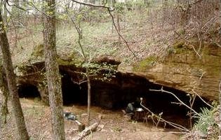
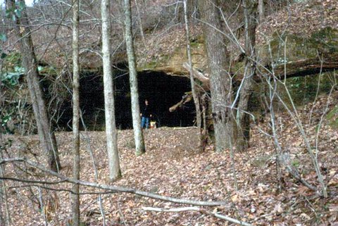
During the late summer of 1996, Jerry Hilliard and Randall Guendling of the Arkansas Archeological Survey (AAS), Gary Knudson and Michael Dryden of the U. S. Forest Service, and the author met at The Narrows rock shelter site (3CW35) in Crawford County, Arkansas. The plan was to capture stereo pairs of some of the spectacular rock art at this site to both test the softcopy photogrammetric method and, importantly, capture quality color film images of the rock art. Vandalism has recently occurred at this site. Several large "peace" signs and other graffiti have been scratched, apparently with another rock, into the back/upper surfaces of the main alcove. Although the overall integrity of the site has been irreparably harmed, fortunately the vandalism has not yet directly impacted the surface of the rock art areas. Therefore, this method of recording will also serve as a means to quantifiably monitor site impacts over time. It is believed that the accurate recording of all rock art sites should be of primary concern to researchers and resource managers alike. Lacking accurate, measurable recordings, it is impossible to assess both natural and human induced site damage. Careful consideration was given the photographic technique used to capture stereo images. This can be extremely important in areas such as The Narrows where natural light cannot be utilized. The main rock art panels at this site are located in semi-dark bluff shelters (see Figures 1 and 2). To attempt to compensate for this lack of natural light and retrieve as much quality information as possible from the petroglyphs, electronic strobe flashlights were used with a small generator to power them. One of the lights was set up to graze the surface of the rock art. This method allows one to perceive subtle relief on shallow petroglyphs. The aperture and shutter speed were controlled through the use of an electronic light meter. It is suggested, as with all archaeological photography, that one brackets the exposures. While we did encounter some problems with this lighting method, we retrieved many high quality images. Most of the problems revolved around the fact that this lighting system was designed for a dark studio use and in the semi-dark shelter the strobe sensors were not always activated to flash together. This is, however, a minor problem.
A control frame constructed of 1/2" metal conduit was used. It could be adjusted from a 45x45 cm to a 2x2 m square by adding extra lengths of conduit. The design allowed us to adjust our camera distance according to the rock art size. This basically enables one to capture close-up images of rock art features or panels by moving the camera closer while still being able to capture the necessary surrounding smaller control frame. In other words, one needs to place the camera further away from larger rock art panels, thus lowering the level of detail capture in the images. To preserve the spatial integrity of the rock art elements but still gather close-up detailed images, the camera was first set up to cover the large panels, then moved progressively closer to finally capture single element images. The camera was kept parallel to the control frame through the use of a self-designed camera movement system. This system was designed for a single camera and was based on a rolling platform. The camera was mounted to the platform, allowing easy movement between the left and right camera stations. The roller system was placed parallel to and level with the control frame/rock art. This allowed the gathering of controlled location information for the camera stations with respect to the rock art. Results This preliminary work has resulted in the capture of high quality color stereo pairs of the main rock art panels at The Narrows. This is viewed as an important data gathering step. Due to use of the studio lights, much detail can be seen in the images. The 35mm slides (Kodak 64 ASA) were then scanned at 7.5 micrometers resolution through the use of a Zeiss/Intergraph product called PhotoScan. This product is a high quality scanner (housed at the Center for Advanced Spatial Technologies courtesy of the Intergraph Corporation) and scans the films in three passes, one for each color band. After compression, a full color stereo pair of 35mm slides requires approximately 20Mb of memory. However, these could be scanned at a much lower (i.e. 15, 30 or 60 micrometers) resolution, greatly shrinking the respective file sizes. The PhotoScan is connected to an Intergraph ImageStation softcopy photogrammetric workstation (also courtesy of the Intergraph Corporation).
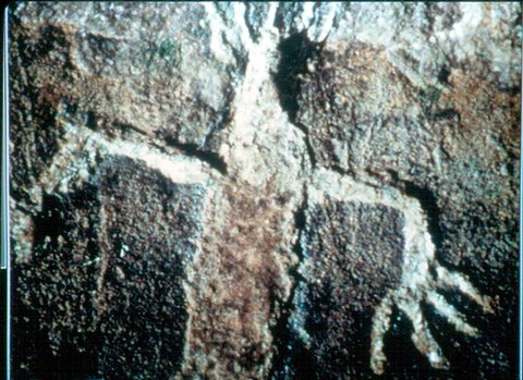
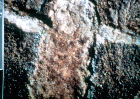
The software demands the input of a variety of parameters and information such as the camera distance, base distance, focal length, film size, etc. before it can compute a photogrammetric solution. Once a solution is reached, the stereo model can then be displayed on the computer screen. Through the use of liquid crystal shutter glasses that are synchronized to the flashing (120/sec) left and right images on the computer screen, one can view the rock art in three dimensions. "The computing power of the Intergraph ImageStation allows the user to move about the stereo pair as if 'flying' over the actual scene or object" (Gisiger et al. 1996: 59-60). One can easily zoom in or out on this three dimensional image to view features at a very detailed level (Figures 3 and 4). This fact allows one to carefully study every square centimeter of the coverage surface and view features that were not even visible in the field. "A large pointing device, called the track-ball, enables the user to control movements along the x, y, and z axes, while dynamically displaying the real-life coordinates of the cursor's current position" (Gisiger et al. 1996: 60).
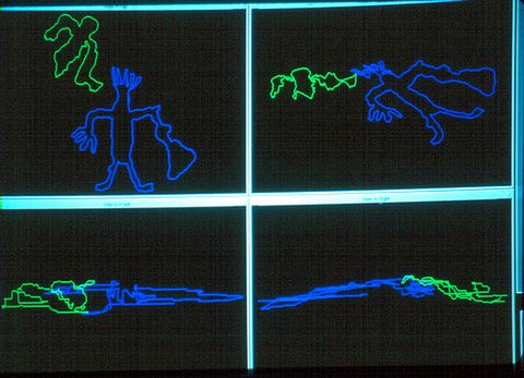
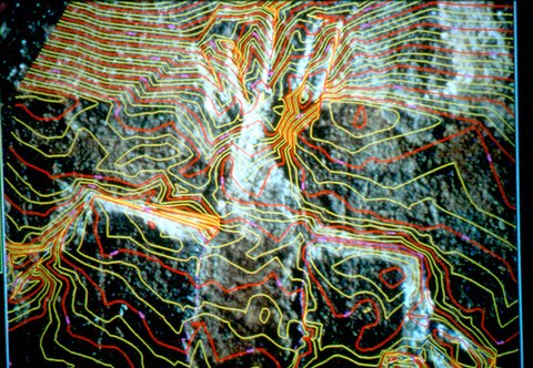
The ImageStation Data Collection environment is interfaced with the Microstation and Microstation Feature Collection CAD software. This allows the three dimensional digitization of rock art features, wall profiles, and other features (Figure 5). Using these tools a digital elevation model (DEM) or contoured surface can also be created (Figure 6).
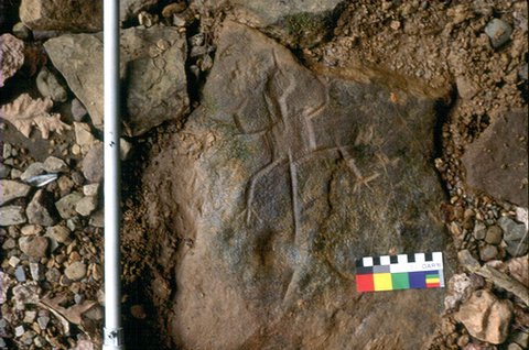
The measurements retrieved from this system are very accurate. When comparing the digitally derived measurements to traditional (i.e. taped) distances they are essentially identical. A ten centimeter scale was placed in some of the stereo pair images (Figure 7). The measurements derived from the three dimensional softcopy image were within a few tenths of a millimeter of 10 cm. The measured difference between manually and computer gathered distances of approximately two meters was less than one millimeter in most cases. It should be cautioned, however, that this high level of accuracy only applies to planar (x and y axes) distances. Depth (z axis) measurements are not as accurate. It is believed that this fact is largely due to lens distortion. Most photogrammetric projects are carried out utilizing a very expensive metric camera that comes with a calibration report that corrects for lens distortion. The high cost of these cameras/films makes them impractical for most archaeological applications. Furthermore, there are methods to correct for lens distortion in 35mm cameras (Fryer et al. 1990).
The photogrammetric recording method not only captures high quality film images but also provides the archiving of high resolution color digital images. This allows the redundancy of archived images for future information needs. It is likely that a digital record such as a CD can provide a stable environment for long term information storage. When using digital images for study, they can easily be copied and transferred to other researchers. Furthermore, digital technology allows the manipulation of contrast, color, and other aspects to better view faint markings. This technique/technology allows one to: (1) View the art in a realistic three-dimensional manner on the computer screen. (2) Accurately measure features with a real world scale. (3) Digitize and extract features in three dimensions. (4) Build DEM's or contoured surfaces. (5) Zoom in or out on features for detail that cannot be retrieved from traditional recording methods. (6) Provides a method to monitor and quantify site impacts. (7) Provides a three-dimensional record for future analysis. While much work remains to be done, this preliminary study has proven the usefulness of this technique and technology for recording and studying rock art sites, and for expanding the use of photogrammetric recording for archaeological field subjects in general. References Cited Anderson, R. C. Bock, F. G., and A. J. Bock Carbonnell, M. Cooper, E. S. 2001a Technological Advances In Rock Art Recording. In Eastern States Rock Art Research Association Newsletter Volume 5 No. 4: 15. 2001b Photogrammetric Recording of Rock Art Elements (41TG201) and a Permian Age Trackway at San Angelo State Park, Tom Green County, Texas. Produced for Texas Parks and Wildlife Department, Austin, Texas. 2001c Photogrammetric Recording and Digital Data Collection of Rock Art Elements at the Roll Site (12CR175) in the Hoosier National Forest, Crawford County, Indiana . Produced for USDA Hoosier National Forest, Bedford, Indiana. Donnelly, B. and J. Fryer Fryer, J., H. Kniest and B. Donnelly Garrison, E. G. Gisiger, A., E. Cooper, Y. Yuan and W. F. Limp Hedges, K. Mendonca, F. J. B. D. C. Pilles, P. J. Price, N. S. Rivett, L. J. Sterud, E. and P. Pratt Turpin, S. A., Watson, R. P., Dennett, S., and Muessig, H. Whitley, D. S. Whittlesey, H. Wolf, P. R. |
