Indians of Arkasnas Homepage


How do we learn about the past?

Indians Before Europeans
American Indian Perspectives
Origins of the Middle World
Creation of the World (Osage)
Creation of the World (Caddo)
Creation of the Sun (Tunica)
The Daughters and the Serpent Monster (Caddo)
How Tlanuwa Deafeated Uktena (Cherokee)
Lightning Defeats the Underground Monster (Caddo)
Chaos into Order
Maintaining Order in Osage Communities
How People Came to Hunt Animals (Caddo)
Origins of Corn (Natchez)
Origins of Fire (Cherokee)
Natchez Sacred Fire
Understanding the World Through Stories
Caddo Creation Stories
Story 1: Creation and Early Migration
Story 2: Creation of Day and Night
Story 3: Origin of Animals
Story 4: Coyote and the Origins of Death
Story 5: Origin of the Medicine Men
Story 6: Lightning and Thunder
Academic Perspectives
Ice Age Migrations
Paleoindians
The Dalton Culture
Archaic Period Cultures
Woodland Period Cultures
The Mississippi Period

First Encounters

Historic Arkansas Indians
The Quapaw Indians
The Caddo Indians
Tunica and Koroa Indians
The Osage Indians
The Chickasaws
The Natchez Indians

Indians After Europeans
Indians and Colonists
Indians in the Old South
Indians in the New South
Indians Today

Current Research
Ancient Foodways
Arkansas Novaculite Project
Bruce Catt
3LO226
Caddo Dance
CARV Project
Research Design
Introduction
Background
Project Goals
Previous Research
Project Organization
Arkansas Archeological Survey
Caddo Nation
Osage Nation
Quapaw Nation
Project Methods
Collection Inventory and Analysis
GIS, Remote Sensing, and Excavation
Summary
References Cited
Project Accomplishments
Project Initiation Meeting
Memorandum
NMAI Inventory
Gilcrease Museum Inventory
LSEM Inventory
UA Collection Inventory
3YE347 Survey
3PP274 Survey
3YE25 Survey
3YE25 Tree Planting
3YE25 Geophysics
3YE25 Excavations
3YE347 Analysis
3YE25 Analysis
3CN213 Analysis
Ozark Reservoir Analysis
Lithic Raw Materials
Year 2 Project Meeting

Writing Prompts

Learning Exercises
Indians and Animals
The Three-Layer Universe
Trade Goods
What is a Map?
Frontier Exchange Economy
Creation Stories
Children of the Middle Waters (Osage)
Origin of the Middle World (Yuchi)
The First People (Caddo)
Origin of the Supreme Being (Caddo)
Origin of Animals (Caddo)
Origin of Corn (Natchez)
Origin of Beans (Tunica)
Origin of Fire (Cherokee)
The Calumet Ceremony in the Mississippi Valley
Marquette Account
Gravier Account
Du Poisson Account
First Encounters: Cultural Perspectives
Gentleman of Elvas: Chapter XXII
Gentleman of Elvas: Chapter XXIII
Gentleman of Elvas: Chapter XXVI
Gentleman of Elvas: Chapter XXIX
Gentleman of Elvas: Chapter XXXII and XXXIII
Ritual Analysis
Caddo Harvest Ritual
Natchez Harvest Ceremony
Smoking Ceremony from the Songs of the Wa-Xo'-Be (Osage)
Transcending Themes

Project Background and History


End of Left Side of Page


Tree Planting at 3YE25

Jami J. Lockhart, Leslie C. Stewart-Abernathy, and George Sabo III
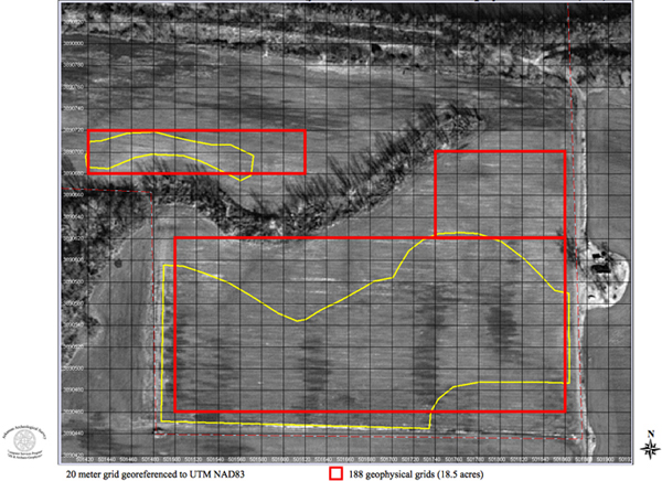
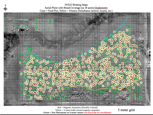
Arkansas Archeological Survey

Geophysical remote sensing for the Carden Bottoms (3YE25) project was designed in part to rapidly generate information about the distribution of archeological features in advance of imminent plans by the National Resource Conservation Service (NRCS) to plant 300 trees within the study area as part of a wooded-wetland reclamation effort. Our mutual goal was to protect significant archeological features from being damaged by the tree planting operation. To accomplish this goal, we first collected gradiometer data along one-meter traverses across the eight hectare area in which trees were to be planted, providing a low resolution view of magnetic anomalies for the entire area. Using geographic information system (GIS) software, we georeferenced these data to the site coordinate system to provide accurate locations on the ground.

tree planting impact area
Tree planting impact area (yellow) and gradiometry survey boundaries (red) at 3YE25.

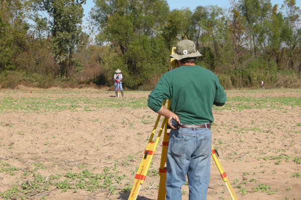
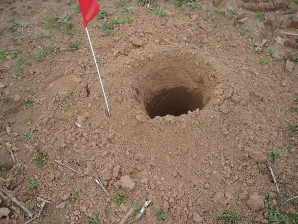
Next, we used GIS to generate a four meter buffer area around all magnetic anomalies that we interpreted as possible cultural features. Using GIS again, we digitized 300 locations for tree plantings in areas outside the magnetic anomalies and surrounding buffer areas. A coordinate list for the recommended tree locations was generated, and we located those points on the ground using laser total stations set up on our main site datum and two secondary datum points. Each tree point was marked with a red pin flag as a guide for planting.

buffers and trees
Map of gradiometer anomalies (red), four-meter buffers (yellow), and tree points (green) at 3YE25.

tree point
Jerry Hilliard (at Total Station)) and John Riggs (with stadia rod) setting pin flags at selected tree planting points.

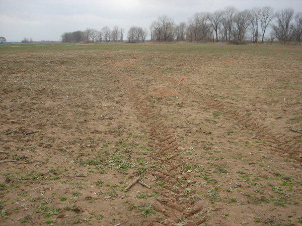
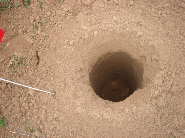
Tree planting by NRCS field staff involved driving a truck-mounted soil auger across the site, stopping at each flagged point to drill a hole, approximately 10 cm wide and 1 m deep. The drilling left a ring of back dirt around each hole. A few days later, small seedlings were planted in each hole.

tree holes
Tree holes excavated by NRCS field crew.

The day after the tree planting operation had been completed, Skip Stewart-Abernathy, of the Survey's research station at the University of Arkansas Winthrop Rockefeller Institute on Petit Jean Mountain, conducted a walk-over survey of the site to examine the drilled holes and back dirt for evidence of buried cultural materials. His circuit across the site enabled him to examine directly or from a short distance all of the 300 tree holes. Close examination was conducted of tree holes drilled near house areas identified in the gradiometer survey and in potential burial areas identified in oral history interviews. Stewart-Abernathy took digital photographs that show about one-third of the tree holes up close and the rest at a distance of up to a few meters.

tree hole and flag
Excavated tree hole with surrounding back dirt pile.

The operation of the drill obscured the soil profile inside each hole from the surface to about 20 cm depth. We know from our excavations across the site that the disturbed plow zone extends to an average depth of 35 cm, so we are confident that this circumstance produced no loss of information about the presence of burial cultural materials. Stewart-Abernathy observed no midden layers, features, or other stratification in any of the tree holes below the upper plow zone horizon. The back dirt surrounding nearly all of the holes was the light yellow brown color that is generally exhibited by undisturbed sediments across the site; only a few holes (about 5% of the total) were surrounded by a slightly darker brown matrix. Stewart-Abernathy also observed no artifacts in the back dirt surrounding the tree holes; surface visibility at the time was excellent though the field was dry and no rain had fallen since the holes had been drilled.

tree hole interior
Soil profile inside excavated tree hole.

From these observations we conclude that the drilled tree holes avoided most if not all high density artifact areas and inflicted no significant damage to any buried cultural materials at the site.

3YE25 Survey
3YE25 Geophysics


| Home | How do we learn about the past? | Indians Before Europeans | First Encounters | Historic Arkansas Indians | Indians After Europeans | Current Research | Writing Prompts | Learning Exercises | Project Background and History |

View Printer Friendly Page


Last Updated: July 14, 2011 at 1:18:04 PM Central Time