Indians of Arkasnas Homepage


How do we learn about the past?

Indians Before Europeans
American Indian Perspectives
Origins of the Middle World
Creation of the World (Osage)
Creation of the World (Caddo)
Creation of the Sun (Tunica)
The Daughters and the Serpent Monster (Caddo)
How Tlanuwa Deafeated Uktena (Cherokee)
Lightning Defeats the Underground Monster (Caddo)
Chaos into Order
Maintaining Order in Osage Communities
How People Came to Hunt Animals (Caddo)
Origins of Corn (Natchez)
Origins of Fire (Cherokee)
Natchez Sacred Fire
Understanding the World Through Stories
Caddo Creation Stories
Story 1: Creation and Early Migration
Story 2: Creation of Day and Night
Story 3: Origin of Animals
Story 4: Coyote and the Origins of Death
Story 5: Origin of the Medicine Men
Story 6: Lightning and Thunder
Academic Perspectives
Ice Age Migrations
Paleoindians
The Dalton Culture
Archaic Period Cultures
Woodland Period Cultures
The Mississippi Period

First Encounters

Historic Arkansas Indians
The Quapaw Indians
The Caddo Indians
Tunica and Koroa Indians
The Osage Indians
The Chickasaws
The Natchez Indians

Indians After Europeans
Indians and Colonists
Indians in the Old South
Indians in the New South
Indians Today

Current Research
Ancient Foodways
Arkansas Novaculite Project
Bruce Catt
3LO226
Caddo Dance
CARV Project
Research Design
Introduction
Background
Project Goals
Previous Research
Project Organization
Arkansas Archeological Survey
Caddo Nation
Osage Nation
Quapaw Nation
Project Methods
Collection Inventory and Analysis
GIS, Remote Sensing, and Excavation
Summary
References Cited
Project Accomplishments
Project Initiation Meeting
Memorandum
NMAI Inventory
Gilcrease Museum Inventory
LSEM Inventory
UA Collection Inventory
3YE347 Survey
3PP274 Survey
3YE25 Survey
3YE25 Tree Planting
3YE25 Geophysics
3YE25 Excavations
3YE347 Analysis
3YE25 Analysis
3CN213 Analysis
Ozark Reservoir Analysis
Lithic Raw Materials
Year 2 Project Meeting

Writing Prompts

Learning Exercises
Indians and Animals
The Three-Layer Universe
Trade Goods
What is a Map?
Frontier Exchange Economy
Creation Stories
Children of the Middle Waters (Osage)
Origin of the Middle World (Yuchi)
The First People (Caddo)
Origin of the Supreme Being (Caddo)
Origin of Animals (Caddo)
Origin of Corn (Natchez)
Origin of Beans (Tunica)
Origin of Fire (Cherokee)
The Calumet Ceremony in the Mississippi Valley
Marquette Account
Gravier Account
Du Poisson Account
First Encounters: Cultural Perspectives
Gentleman of Elvas: Chapter XXII
Gentleman of Elvas: Chapter XXIII
Gentleman of Elvas: Chapter XXVI
Gentleman of Elvas: Chapter XXIX
Gentleman of Elvas: Chapter XXXII and XXXIII
Ritual Analysis
Caddo Harvest Ritual
Natchez Harvest Ceremony
Smoking Ceremony from the Songs of the Wa-Xo'-Be (Osage)
Transcending Themes

Project Background and History


End of Left Side of Page

What is a Map?

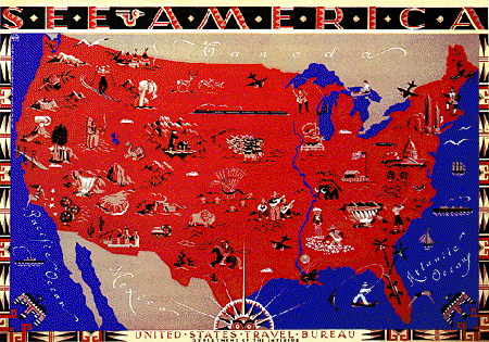
When we think of maps, the first image that pops into our minds is usually a drawing or picture that shows some part of the Earth’s surface, like the image below. If we think about it some more, we may recall that there are may kinds of maps: maps of the hallways or classroom locations at our schools, maps of bus routes or subway routes in our towns, of maps of constellations in the sky.

An example of a modern map, showing various tourist points of interest in the United States. A stylized “American Indian” design is used for labeling and to decorate the border.

These examples show that a map is a representation (usually two-dimensional, or flat) of any surface or area. Here is a map made by a Chickasaw Indian around 1723 for Francis Nicholson, the Governor of British Carolina. It may not look like a map to you, but it contains all the basic elements found on any map. What are these elements?

“A Map describing the situation of several Nations of Indians between South Carolina and the Massisipi …” Courtesy of the Public Record Office, London [CO 700/6(2)]. All rights reserved, further reproduction is prohibited.


Direction

All maps indicate direction: which way are things located? Direction is often indicated relative to the orientation of the map, where one edge is “up” and the opposite edge is “down.” Directions sometimes correspond to the major points of a compass (North, East, South, and West). How is direction indicated on this map? (Hint: the long line on the map’s left-hand side is the Mississippi River, and the long line along the bottom of the map is the Gulf Coast.)

Answer

This map is oriented to compass directions; the top edge is North.


Distance

Maps also usually indicate distance: how far apart are things shown on the map? Absolute distances are indicated by a scale (for example, 1 map cm. equals 1000 m on the ground). Distance can also be indicated in a relative manner by how closely or how far apart separate elements are placed on a map. How is distance indicated on this map?

Answer

Relative distances are indicated on this map. Look at the large circles representing Indian towns. These are separated by relative distances; the closer the circles, the shorter the real distance separating them.


Content

All maps are made to show what is located in the area that’s represented. The content of this Southeastern Indian map includes topographic features (rivers and coastlines), a set of closely related Indian and English settlements (indicated by the large circles), a larger set of other communities that are more distant geographically as well as socially (indicated by smaller circles; the ones marked with an “F” are Indian villages allied with French colonists), and pathways or trails connecting these settlements. See if you can identify the following items:

  1. a topographic feature
  2. a French-allied and an English-allied Indian town
  3. a connecting trail


Trade Goods
Frontier Exchange Economy


| Home | How do we learn about the past? | Indians Before Europeans | First Encounters | Historic Arkansas Indians | Indians After Europeans | Current Research | Writing Prompts | Learning Exercises | Project Background and History |

View Printer Friendly Page


Last Updated: March 3, 2007 at 1:30:15 PM Central Time