
Sarah Shepard and Teka McGlothlin
Archeology often focuses on the artifacts that are unearthed during an excavation. While artifacts are undoubtedly interesting to see, they lose their meaning if a record of their provenience isn’t maintained. Field notes, excavation level sheets, sketch maps, and other kinds of recordkeeping are invaluable to understanding the past. Archiving these documents is one focus of the Registrar’s Office of the Arkansas Archeological Survey. The office serves as the central repository for all site files, project records, and countless other archival collections.
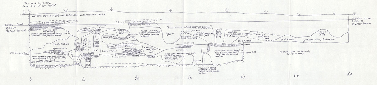
Archeologists record many forms of data while in the field. The photo shown above is a profile view of a site in eastern Arkansas taken at the end of an excavation in 1984 by former UAPB Station Archeologist Dr. John House. The hand drawn map shows the complexities of sites and how much attention must be given to fully understand what has taken place at any given location in the past. The different colors and textures of soil can indicate specific actions and moments in time. The top layer of the photo shows historic debris and mixed soil, while other prehistoric indicators like charcoal, daub, and middens are present throughout the lower levels. Archeologists can interpret the mixture of these textures and read the soil to understand the use of this area over time.
The Survey archives numerous maps like this one for researchers and professionals to access. We have on file over 7800 projects undertaken by Survey archeologists as well as Federal and State agencies and cultural resource management firms over the course of the last 54 years. There are field notes, sketch maps – both oversized like this one and small artifact sketches, photographs, slides, and final reports, among a vast array of other accompanying information. Over the last several years, we’ve begun working on digitizing these records to ensure they are preserved and available for use in the future. In addition to these projects, there are over 50,000 documented sites across the state of Arkansas. Each location has a site file with data including site type, physical location, associated collections, collection/documentation methods, and assorted notes. The Registrar’s Office is responsible for assigning the trinomials – the unique identifying system developed by the Smithsonian Institution – associated for each archeological site.
Additionally, Arkansas has been home to many great archeologists. Many of these individuals have donated material generated throughout their dynamic careers to the Registrar’s Office for safekeeping. The Registrar’s Office preserves the work of former federal and state employees, retired professors and Survey station archeologists, as well as avocational archeologists.
The Arkansas Archeological Survey archives many different types of records both at the Coordinating Office in Fayetteville and at the various Research Stations across the state. By doing so, we’re able to preserve the history of Arkansas in more ways than just artifact curation. It’s important to remember the old adage, “it’s not what you find, but what you find out.” Maintaining the archeological record with site and project documentation, while continuously building on the lessons we’ve learned, is the main way to do that!