Sarah Stuckey, ARAS-ASU Research Station
"Archeology is..." series - February 2025

""
Sketch map of the Knights of Pythias cemetery.
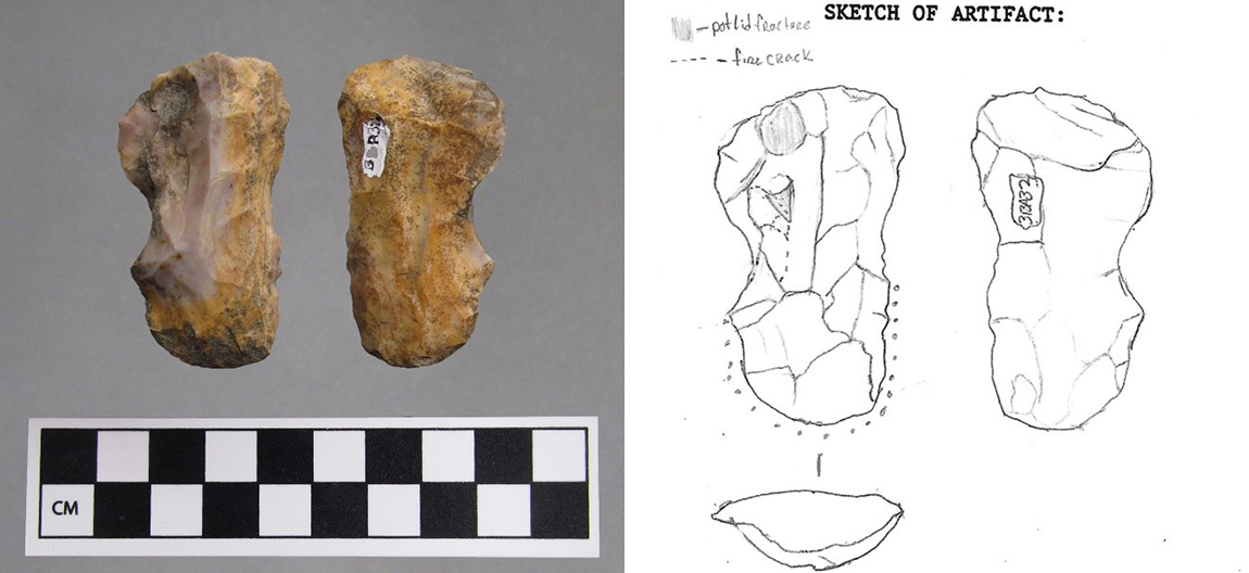
Archeologists have to record information throughout the archeological process. While written descriptions are usually the focus of recording information, visual representations help bring those words to life. Archeologists create these visual representations with scientific drawings. What makes a drawing scientific? The addition of specific details and identifying markers that bring the visual representation into the real world. 
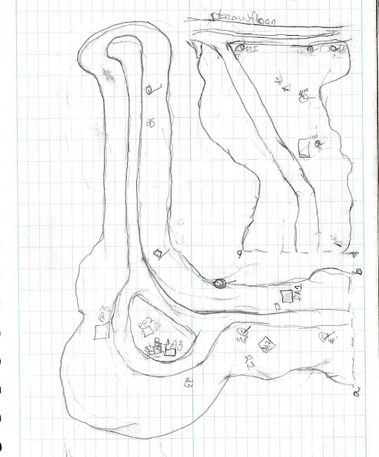
Sketch maps are the most basic form of visual representation in archeology. Sketch maps are drawn while initially recording sites or during the initial stages of excavation. They are usually rough and semi-accurate, but they help archeologists understand the layout of a site. A sketch usually consists of roads, buildings, and visual boundaries of the area investigated. Archeologists do not have to be adept at drawing to produce a sketch map. An archeologist only needs basic dots, lines, and shapes to produce an image that visualizes what they see in the landscape. 
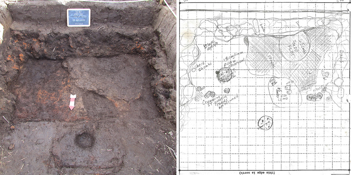
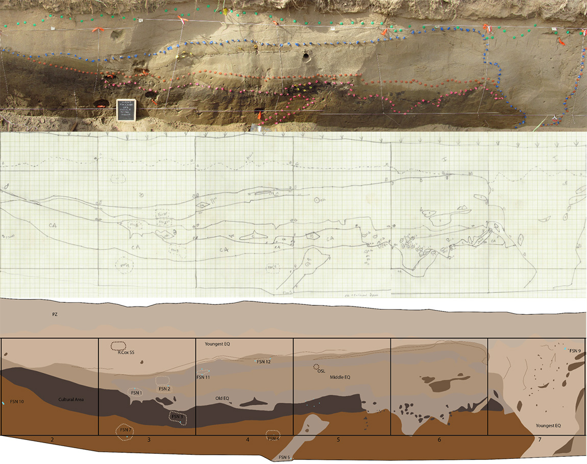
During excavations, archeologists use both photography and drawing to represent what they see. These two methods work hand in hand. Some things are more visible in a photograph than a drawing and vice versa. For example, archeological excavation can involve subsurface testing in levels. This allows the archeologist to see what the excavation area looks like at specific depths. Once an excavation reaches a level, the archeologist takes a photograph and then draws a plan view of the level onto a level form. The form has a grid and, while drawing, archeologists use rulers and measuring tapes to make sure what they draw is as close to exact as possible. Level form drawings show features, soil color differences, soil texture changes, visible artifacts, and occasionally special artifacts removed from specific locations within a level. This allows the archeologist to see and remember the placement of an object once an excavation is complete. 
""
Photograph and level form from a unit excavated at the Greenbrier site in the fall of 2023.
In the lab, archeologists choose diagnostic artifacts to analyze beyond basic identification. An example of this would be recording stone tools. Recording stone tools involves measuring specific attributes such as length and thickness, identification of raw material, and describing features like heating and breaks. Both photographs and drawings are made of the stone tool for the same reason stated above. Some things are more visible in a photograph than a drawing and vice versa.  A photo shows color, flake scars, and weathering that would not be visible in most drawings. A drawing can show heat damage, grinding, fractures, and usewear that would go unnoticed or overlooked in a photograph. The archeologist photographs both sides of the artifact and then uses digital processes to combine the photos into one graphic. This graphic can be used in reports and presentations. While recording its attributes the archeologist will draw the stone tool. The drawing will show the features stated above but will also be scaled to the actual size of the artifact. The drawing contains both sides of the stone tool as well as a cross-section view.  
""
Merged graphic and drawing of a stone tool from the Larry Billings Collection.
Archeologists need representations of the visual data they collect. Sometimes the photographs and drawings do not clearly represent the details of a site, feature, or artifact. This is when digital illustration comes in. For example, an area an archeologist wants to see is larger than what can be displayed in one photograph or drawing alone. To solve this, the archeologist takes several photos to cover the entire area and make several drawings as well. The archeologist can then use computer software to merge the photos into one image and align the drawings into one graphic. There are issues with digitally merged photographs, however. Merging can cause distortions and an area where photos overlap is easy to spot. Aligned drawings do not have these issues. The archeologist’s drawn images are to scale so the drawings can be placed side by side with no overlapping or distortion. The issue with drawings is that they lack color, and the drawn features can become jumbled to the eye and confusing. Using both the merged photo and the aligned drawing, an archeologist can use computer software to create a digital illustration. The illustration is accurate to scale and colorized to show the relationship and differences between features. The digital illustration is clear and informative making it valuable for public presentations and publications.
""
Merged photograph, aligned drawing, and digital illustration of a section of a wall trench depicting an earthquake feature from the Old Town Ridge site.
Archeologists do a lot of work that requires knowledge from other disciplines. With all the artifact identification and interpretation at the forefront of archeological investigation, scientific drawing can seem like an afterthought. Scientific drawing is vital throughout the archeological process; from project inception to public presentation of the knowledge gained.  

“Archeology is…” Series Information

In this series we plan to highlight the many and various things that Are Archeology, from Art to Zoology and everything in between. We hope you enjoy learning a bit more about the variety of things that archeologists do and specialize in and maybe it will inspire you to be an archeologist even if you love learning about things in another field. You can find all the entries here.