Jami J. Lockhart, PhD, Arkansas Archeological Survey
"Archeology is..." series - April 2024

""
Ground penetrating radar (GPR) is used to detect buried objects, voids, or other subsurface changes.
Geophysics is a natural science that studies physical processes and properties of the earth. The prefix “geo” is defined as relating to the earth, and “physics” describes relationships between matter and energy. In this brief description, we will also add “archaeo” to “geophysics” because we are using geophysical methods to study human history and prehistory.
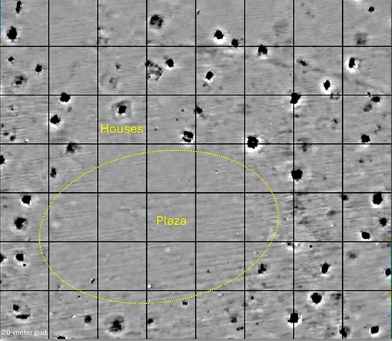
Consider past civilizations that have dug in the soil (trenches, moats, irrigation channels, wells, storage pits, graves…), piled the soil (mounds, floors, defensive embankments, paths…), and constructed houses (wood, cane, clay, stones, bricks, fire hearths…). Measurable traces of these historic actions and materials remain in the soil. Even simple day-to-day living activities, such as food preparation and waste disposal, can leave lasting evidence of human occupation.
We measure ancient changes within the soil using geophysical remote sensing technologies that provide information and enable maps detailing underground archeological features—before (and even without) excavation. These devices work by precisely measuring frequencies and wavelengths of electrical and magnetic energy that comprise portions of the electromagnetic spectrum. Traces of human activities and artifacts remain detectable in the soil hundreds (and thousands) of years after the people that left them have lived and died.
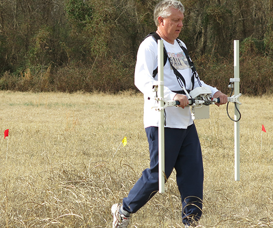
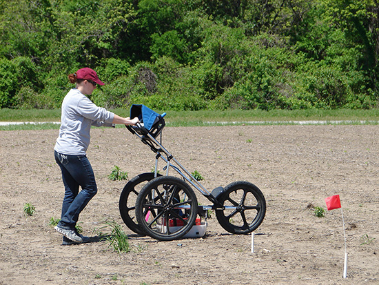
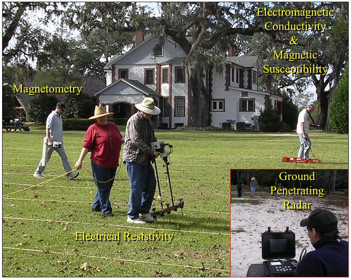
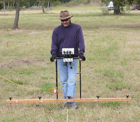
Archaeogeophysical remote sensing is now a fundamental part of archeological investigation. We routinely use multiple technologies such as magnetometry, electrical resistance, electromagnetic conductivity, magnetic susceptibility, and ground penetrating radar to study long-past human activities that have resulted in variations to soil moisture, texture, compaction, burning, artifact composition, and cultural soil enrichment.
""
This image illustrates different remote sensing tools being used to collect data within a surveyed grid pattern.
In archeological applications, geophysical data are typically collected at close intervals for a volume of soil at closely-spaced and predetermined locations—often within a surveyed grid pattern enabled by global positioning system (GPS) technology to pinpoint the location of each geophysical measurement collected.
Magnetometry (measured in nanoteslas) detects human changes to the earth’s natural magnetic field and alignment—brought about through cultural activities such as burning, soil movement, introduction of ferrous metals, or other cultural alterations to the soil. Topsoil is commonly more magnetic than subsurface soils, so long-past human actions such as digging and/or heaping are detectable. Anthropogenic burning (i.e., hearths) and firing (i.e., ceramic kilns) change the magnetic strength and orientation (inclination and declination) of archeological features, and these changes are commonly identifiable using a magnetometer.
Electrical resistance (measured in ohms) detects human modifications that affect soil moisture and content, which alters the efficiency with which electricity can be conducted through the ground. For example, archeological features that involve digging, heaping, or soil compaction will conduct electricity either more or less efficiently than the surrounding unaltered soil.
""
Electrical resistance is used to detect human modifications that affect soil moisture and content.
""
This gradiometer imagery reveals buried pre-contact structure remains that surround a civic/ceremonial plaza, discovered beneath a modern agricultural field.
Electromagnetic conductivity data (measured in MilliSiemens) is often compared as the theoretical inverse of electrical resistance. If a material is more conductive, it is less resistant to the flow of electricity. However, conductivity data often contribute unique details due to a different technological configuration and unit of measure.
""
Gradiometers (magnetometers) are used to detect human changes to the earth’s natural magnetic field and alignment brought about through cultural activities such as burning, soil movement, introduction of ferrous metals, or other cultural alterations to the soil.
Magnetic susceptibility (measured as a unitless constant) gauges the extent to which culturally altered (paramagnetic and ferromagnetic) soils and features react to an induced magnetic field. In other words, it measures how well materials will accept and briefly hold a magnetic charge.
Ground penetrating radar (GPR) data are measured in nanoseconds using antennae that determine depth of signal penetration as measured in megahertz. These devices emit pulses of electromagnetic energy downward from the surface, and then measure the return time, depth, and magnitude of energy reflected to an antenna at the surface. GPR is used to detect differential densities in locating buried objects, voids, or other subsurface changes.
Following data collection, all these types of geophysical remote sensing data are downloaded from an integrated digital data collector and processed using a computer to provide maps revealing the location of subsurface features. The information can be used to inform archeological excavations or interpreted as standalone records indicating past human activities and occupation.
Multisensor geophysical coverage of entire pre-contact towns not only enables pinpointed excavations, but also provides information about site organization, structure location, size, shape, orientation, density, architecture, age, and preservation. What may look like an ordinary bean field on the surface today may hold buried evidence of human lifeways in the distant past. Subsurface remote sensing, along with aerial technologies such as LiDAR, are continuously driving discoveries of past cultural landscapes and lifeways in Arkansas and around the world.
Additional References:
Clark, A. 2003. Seeing Beneath the Soil. Prospecting Methods in Archaeology. Routledge. London.
Conyers, L., Goodman, D. 1997. Ground-Penetrating Radar: An Introduction for Archaeologists. Altamira Press. Plymouth.
Gater, J., Gaffney C. 2003. Revealing the Buried Past: Geophysics for Archaeologists. Tempus. Reading Berkshire.
Johnson, J. (ed.). 2006. Remote Sensing in Archaeology: An Explicitly North American Perspective. University of Alabama Press. Tuscaloosa.
Kvamme, Kenneth L. 2006. Magnetometry: Nature’s Gift to Archaeology. In Remote Sensing in Archaeology: An Explicitly North American Perspective. J. Johnson (ed.) p. 205-233. University of Alabama Press. Tuscaloosa.

“Archeology is…” Series Information

In this series we plan to highlight the many and various things that Are Archeology, from Art to Zoology and everything in between. We hope you enjoy learning a bit more about the variety of things that archeologists do and specialize in and maybe it will inspire you to be an archeologist even if you love learning about things in another field. You can find all the entries here.